|
|
"To us
all towns are one, all men our kin. |

| Home | Whats New | Trans State Nation | One World | Unfolding Consciousness | Comments | Search |
|
|
"To us
all towns are one, all men our kin. |
| Home | Whats New | Trans State Nation | One World | Unfolding Consciousness | Comments | Search |
Home > Struggle for Tamil Eelam > Boundaries of Tamil Eelam > Ptolemy's World Map
BOUNDARIES OF TAMIL EELAM
Ptolemy's World Map, circa 150 A.D.
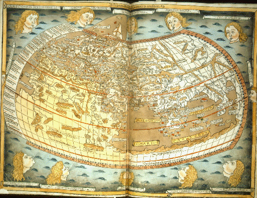
Copyright © 1997, The British Library Board
British Library, Maps 1.d.2
Ptolemy's world map, republished in 1482. Ptolemy (c.100-168) the Greek astronomer and the author of works on physics, mathematics, optics and geography, produced the data for creating a world map in about 150 AD. Unfortunately, none of his maps survived and his work was lost to the West until the Renaissance. Scholars in the 15th century recreated Ptolemy's map using the instructions in his work Geography, which explain how to project a sphere onto a flat piece of paper using a system of gridlines - longitude and latitude.
Ptolemy's map consists of the world known to him; he does not speculate on the unknown, and as he worked in Alexandria the map is most detailed round the Mediterranean. There are only three continents: Europe, Asia and Africa. The two red lines are the Tropics of Cancer and Capricorn; the sea is light brown, the rivers are in blue and the mountains in dark brown. The surrounding heads represent the major winds.
From Portico - The British Library's Online Information Server