|
TAMIL HERITAGE...
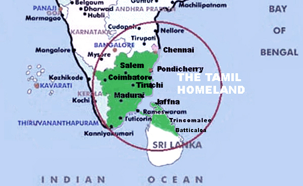
the Tamils are an ancient people
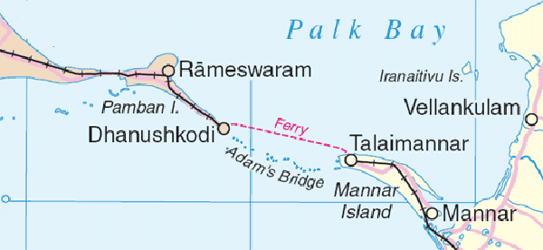
Palk Straits
Palk
Straits - A Narrow Stretch of Shallow Water that
Divides the Tamil Homeland
From Wikipedia
- "The Palk Strait is a strait that lies between the
Tamil Nadu state of India and the island nation of
Sri Lanka. It connects the Palk Bay to the northeast
(and thence the Bay of Bengal) with the Gulf of
Mannar to the south. The strait is 40 to 85 miles (64
to 140 km) wide. Several rivers flow into it,
including the Vaigai River of Tamil Nadu. The strait
is named after Robert Palk, who was a governor of
Madras Presidency (1755-1763) during the British Raj
period.
It is studded at its southern end with a chain of low
islands and reef shoals that are collectively called
Adam's Bridge (or the original name Rama's Bridge).
This chain extends between Dhanushkodi on Rameswaram
in Tamil Nadu and Talaimannar in Mannar in Sri Lanka.
The island of Rameswaram is linked to the Indian
mainland by the Pamban Bridge.
The shallow waters and reefs of the strait make it
difficult for large ships to pass through, although
fishing boats and small craft carrying coastal trade
have navigated the strait for centuries. Large ships
must travel around Sri Lanka. Construction of a
shipping canal through the strait was first proposed
to the British government of India in 1860, and a
number of commissions have studied the proposal up to
the present day. The most recent study of the
Sethusamudram Shipping Canal Project, as it is now
called, was an environmental impact assessment and a
technical feasibility study commissioned by the Tamil
Nadu government in 2004.
Like the English Channel, the Palk Strait has been
taken up as a challenge by many long-distance
swimmers.
The Indian epic poem Ramayana, written thousands of
years ago in Sanskrit and an important Hindu text,
recounts how Rama, with the help of an army of
vanaras, built a bridge of stones across the sea to
Lanka to rescue his wife Sita from the Asura king
Ravana. The Ram Karmabhumi movement, encouraged by a
NASA satellite photograph which they say proves that
remnants of this bridge still exist, was formed to
prevent the shipping canal from being built.
The name Adam's Bridge is a later name than Rama's
bridge and derives from the story that South India or
Sri Lanka was the site of the biblical earthly
paradise, and that Adam's Bridge was created when
Adam was expelled from paradise."
Adam's Bridge across Palk Straits
3,500 years old
The New Indian Express, Madurai. 19 February
2003
The land bridge (shallow coral formation), popularly
known as 'Adam's Bridge' and reputed to be the
remains of the bridge built by Lord Rama, is only
3,500 years old and not 1.7 million years old,
according to the findings of the Centre for Remote
Sensing (CRS) of Bharathidasan University, Tiruchi. A
CRS team led by Dr S. M Ramasamy engaged in
unraveling the geological processes that took place
along the Tamil Nadu coast during the last 40,000
years has come up with starting facts.
A NASA satellite picture had brought the existence of
a stretch of land bridge into sharper focus.
According to mythology, the 'bridge' was built by
Ramah 1.7 million years ago. But NASA didn't give any
credence to this claim. Some reports had mentioned
that it was only a coral reef dating back to 1.7
million years. Historians, too, don't subscribe to
the claim linking this stretch with Ramayana. Besides
the NASA pictures, those snapped by Indian Remote
Sensing satellites also showed the Adam's bridge,
between Dhanushkodi in the west and Talaimannar in
the east.
Detection of bundles of ancient beaches - between
Thiruthuraipoondi and Kodiyakarai-in satellite
pictures and carbon dating of such beaches showed
that Thiruthurajpoondi beach dates back to 6,000
years and Kodiyakarai to 1,100 years.
This indicated that the sea was near
Thiruthuraipoondi 6,000 years ago and reached
Kodiyakarai around 1,100 years ago. The IRS satellite
picture also showed that the beach at Thiruth
uraipoon continued up to Ramanatha puram and further
down to Thoothukudi, three km from Manamelkudi, 2.5
km west of Thondi and 3 km from Devipattinam.
Carbon dating of ancient beaches found west of
Uchichipuli in Ramanath puram district put their age
at 3,500 years. These were clear examples that the
sea had receded from Thiruthurai poondi and
Kodiyakarai as well as from Ramanathapuram to the
west of Unhchipuli, around 3,500 years ago. The sea
may have receded to Pamban only during this
period.
Because of such divergent littoral currents, there
remained a current shadow zone between Dhanushkodi
and Talaimannar and hence the sand brought by the
currents had been dumped in a linear pattern in the
current shadow zone. Corals might have accumulated
over these linear sand bodies, later on Ramasamy
said.
So the land bridge is only the sand, which had begun
accumulating in the current shadow zone 3,500 years
back, and continues to the present day. Therefore,
the age of the Adam's bridge could only be 3,500
years old, he asserted.
But, as the carbon dating of the beaches roughly
matches with the dates of Ramayana, its linkage with
Ramayana needs to the explored, Ramasamy said. One
thing that must be appreciated is the knowledge of
our ancestors on the land-ocean configuration, he
added.
|