|
|
"To us
all towns are one, all men our kin. |


| Home | Whats New | Trans State Nation | One World | Unfolding Consciousness | Comments | Search |
|
|
"To us
all towns are one, all men our kin. |
| Home | Whats New | Trans State Nation | One World | Unfolding Consciousness | Comments | Search |
CONTENTS OF |
| Sethusamudram Corporation |
| Hindu Council, UK calls for Designation of Gulf of Mannar as World Heritage Site, 11 November 2008 |
| Sethusamudram Project: EconomicViability - Jacob John, 21 July 2007 |
|
Appeal by Manitham to UN Secretary General, 4 April 2005 "...the Sethusamudram Ship Canal Project (SSCP), will undoubtedly change the face of the earth in two countries and might exacerbate the possibility of sudden natural disasters such as Tsunamis, Tidal waves or Cyclones..." [see also Hindu Report] |
| Manitham urges investigation by 'Independent International Experts' 17 September 2004 |
|
Radio Veritas: Sri Lanka concerned over Indian move to dredge Palk Straits 17 September 2004- " Sri Lanka Thursday (16 September 2004) expressed concern over Indian moves to dredge the shallow sea dividing the two neighbouring nations to allow international shipping to bypass the island. The government here said in a statement that the ambitious Indian project could take away shipping from Colombo's main port and also pose a security threat to the smaller island republic. India's ministry of shipping has begun work on a project to create a canal through the Palk Straits to link the east and west coasts of India so that shipping between the two points need not go round Sri Lanka. "The government of Sri Lanka is concerned that there will be a number of serious implications for Sri Lanka if the proposed project is implemented by the government of India," the Sri Lankan government said in a statement. It said the Indian plan, known as the "Sethusamudram project," could affect international sea traffic now using Colombo port and would have a negative impact on the environment and on the livelihood of Sri Lankan fishermen. "Since the seas of the northeast of Sri Lanka have an important bearing on security issues, it is also identified as an area for security concern," the statement said. It said the cabinet had appointed a ministerial team involving the ministers of defence and foreign affairs to study all the implications of the Indian project on Sri Lanka. The former Sri Lankan government had proposed a land bridge to connect the two countries over what is known as "Adam's Bridge," a cluster of sand dunes stretching about 30 kilometres (18 miles) between the two neighbours. The bridge project, which could have effectively stopped clearing of a shipping lane, was shelved." Source: AFP |
| `Non-Government Organisations of recent origin have been opposing the Sethu Project' - N K Ragupathy, 10 September 2004 |
| Sethu Project : Puthiya Tamizhagam president, K. Krishnaswamy, expressed apprehension over its adverse impact, 10 September 2004 |
| Sri Lankan environmentalist body objects to Indian project, 7 September 2004 [see also Position Paper of Environmental Foundation] |
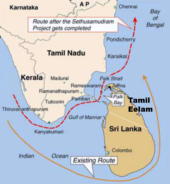
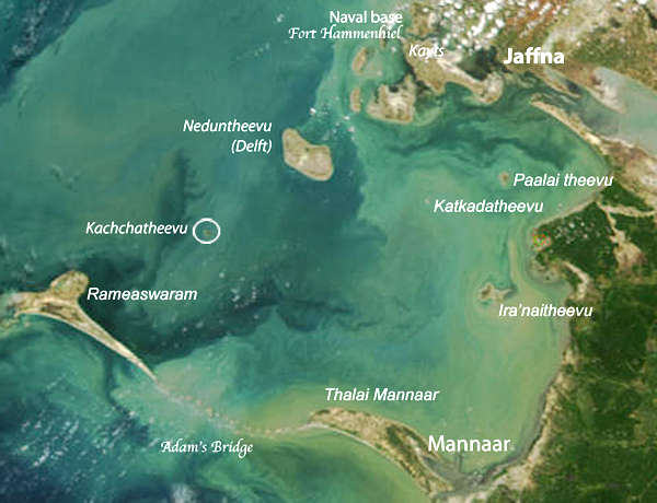
| Sethu Samudram Project , 1 April 2004 "The project proposes linking the Palk Bay and the Gulf of Mannar on the east coast of India by creating a shipping canal through Rameswaram Island, which would provide a continuous navigable sea route around the Indian Peninsula. ..The project was originally conceived in 1860 by the British Commander A.D. Taylor of the Indian Marines.. " |
|
Tamils - a Nation without a State
Tamil Nadu - தமிழ் நாடு Sethusamudram Ship Canal Project Report by Dr. P. Sivalingam
|
|
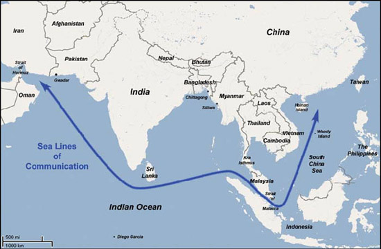
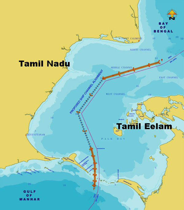
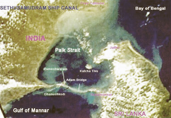
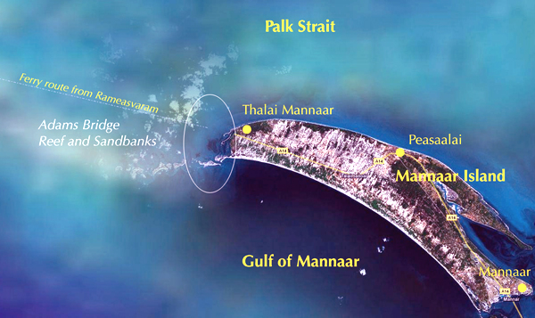
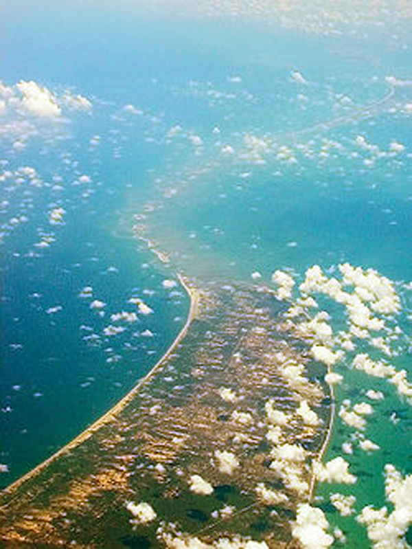
India had maritime trade with various countries of the world since time immemorial. Shipping trade among the various coastal ports both on the west and east coast was also going on for a very long period. India has a peninsular coast of 3554 nautical miles. However, it is rather unfortunate that India does not have a continuous navigable sea lane running within her territorial waters. Consequently, ships from the east coast of India to Tuticorin have to go around Sri Lanka. This is because of a Sand Stone Reef, called Adam's bridge, at Pamban near Rameswaram between the Southern-Eastern Coast of India and Talaimannar of Sri Lanka. The depth of the sea in this portion is very shallow and is hardly about 11 feet only. Because of this shallow depth, the ships have to go around Sri Lanka increasing the travel distance considerably, when they have to call at ports on the East coast of India like Vishakapatnam, Pardeep, Calcutta and Haldia. In order to reduce the steaming distances and take
advantage of navigation along the coast within our territorial
waters, a number of proposals were considered for cutting a Ship
Canal called the Sethusamudram Ship Canal through Rameswaram island,
to connect the Gulf of Mannar with Palk Bay.
All these proposals were not given due consideration
and were kept in cold storage. The committee was of strong view that the two
projects namely the Sethusamudram Canal and Tuticorin Harbour were
very closely inter-related and should be taken up and executed as
part of one and the same project. They also found after careful
evaluation of costs and benefits, the project was feasible and
viable. This proposal showed that the savings on distance
between the various ports will range from 259 to 424 kilometers.
After Tuticorin Harbour Project was sanctioned in 1963, Govt of
India decided to include Sethusamudram Project for advance action.
In Pursuance of this, a High Level Committee was formed with Dr.
Nagendra Singh I.C.S., Secretary, Ministry of Shipping and
Transport, as Chairman and the Committee appointed in 1965 Shri C.
Venkateswaran, Retd. Development Advisor (Ports) as Chief Engineer.
The Madras Govt set up a special Engineering cell with a
superintending engineer and named Shri R. Natarajan I.A.S as Project
Officer, to collect statistics on shipping traffic and other data. (1) boring 2(2) Hydrographic surveys Besides model studies were conducted at Central
Water and Power Research Station, Khadakwasla. Also studies
regarding time required to pass through the ship canal, waiting
period, net savings in terms of time, distance and cost of fuel,
were made. The investigations were completed in 1967 and the report
submitted in May 1968 suggesting the technically feasible and
cheapest alignment along Rameswaram crossing. The cost of the
Project was estimated as Rs. 37.46 crores. Projection of traffic and
revenue was made. It was projected that the foreign ships transits
to Indian ships transit was 73:27. They decided to collect necessary factual data and
descriptive information materials and suggestions relevant to the
project from Govt departments Chambers of Commerce, Members of
Parliament, Members of State Legislature and members of the public
ain the form of memorandum. The committee had sittings at Tuticorin,
Ramanathapuram, Madurai, Madras and received representations. Growth of Tuticorin Port and development of
industries in and around Tuticorin would facilitate faster movement.
The implementation of the project would create further opportunities
to promote coastal traffic throught Tuticorin. Representatives of
Political parties, M.Ps, M.L.As, M.L.Cs also stressed the urgency of
taking up the project. It was also brought out that the project
would enable exploitation of the fisheries wealth of Palk Bay, Gulf
of Mannar and promote reefer trade in the region. Also, development of industries like building boats and trawlers, repairs and maintenance of these vessels, would come up besides fish processing centers, freezing plants etc. Island Fisherman's Associations pleaded to shilf the alignment to the mainland near Uchipuli as fisherman and pilgrims to the temple and public would find it difficult to move from one port to the other. On inspection, the committee noted that there was
heavily built up residential area in the Rameswaram alignment and
examined an alternative alignment across Dhanushkodi east of
Rameswaram temple. After investigations and study of the coastal
morphology in relation to the latest hydrographic chart, the
committee chose the K-alignment across Dhanushkodi west of
Kothandaramasamy Koil. |
|
|
|
|
|
|
|
|
|
|
|
|